

As part of the Women+ in Geospatial mentorship programme, the cohort produce a ‘Legacy’ in their mentorship groups or mentor/mentee pairs. The aim of the Legacy is to give pairs/groups the opportunity to create something as a Legacy of their experience in the programme. The Legacy gives mentorship participants the chance to work towards a collective goal and a way to commemorate their mentorship journey.
This Legacy Gallery showcases the Legacy of the Women+ in Geospatial mentorship cohorts.

Geospatial Career Guide for Career Changers.
Authors: Mairin Williams, Victor Catalan (mentor)
Tags: 2024 Cohort, Guide, Transderable Skills, Geospatial Industry
This guide is for anyone considering a career change into the geospatial industry—a field that combines data, technology, and location to solve real-world problems. This includes understanding transferable skills, learning experiences, and overcoming barriers as a woman or minority.

Machine Learning in land cover classification | Khartoum, Sudan
Authors: Roxana Nazarie, Divya Sharma, Choukouriyah Arinloye, Naomi Rop, Nisreen Mahmoud
Tags: 2024 Cohort, LULC, Khartoum, 2003-2023 change
Supervised Machine Learning approach to generate LULC maps for a 20-year period using Landsat satellite imagery. The results reveal substantial urban expansion between 2003 and 2023 and the urgent need for sustainable urban planning and adaptive land management.

An Initial Investigation of Pollution Patterns (PM2.5) on the Ugandan schools
Authors: PhD Jeena George, MSc. Ampumuza Desire
Tags: 2024 Cohort, Pollution, PM2.5
This study investigates pollution patterns, specifically PM2.5, using a space-time analytical approach in relation to the spatial distribution of school locations in Uganda. Although the PM2.5 data analyzed spans from 1999 to 2016 and may be considered outdated, the spatial and temporal patterns it reveals are invaluable. These insights are crucial for understanding long-term exposure trends and assessing their implications for school environments.

Identifying High Yield Zones For Teff Cultivation.
Authors: Kristen OShea, Ephrata Yohannes
Tags: 2024 Cohort, Teff Yield, Tigray, Agricultural recovery
Identify regions in Tigray with high potential for Teff yield to support post-war agricultural recovery.

Bolivia, a developing crisis
Authors: Lily Penaranda Ferrufino, Eryne Sheffield
Tags: 2024 Cohort, Bolivia, Latin America, Crisis, Natural Resources
My legacy project aims to showcase the ongoing crisis in Bolivia. Due to the government’s lack of transparency, official data is not readily available for people to understand what is happening. I intend to offer a virtual space where people can access interesting data about the country freely.

Raquel’s Portfolio
Authors: Raquel Trejo, Kassie Keeney-McGurk
Tags: 2024 Cohort, Online Portafolio, Achievements & Skills
To maximize Raquel’s achievements as well as highlight her skills it was decided best to create an online portfolio. This online portfolio would be continuously updated in accordance to Raquel’s work and academic history.

Comparative analysis of Solid Waste Management practices. A case of Kampala, Bengaluru and Indore
Authors: Immaculate Asiimwe, Ülcan Türkkan, Rachel Mba, Sowmyashree M V, Puspa Sharma, Gloria Owona (Mentor)
Tags: 2024 Cohort, Waste Management, GIS, Bengaluru and Kampala
This research is about waste management and how we improve its practices in Bangalore and Kampala, by taking an example of Indore.

Heat wave, urbanisation and limited green space; a case study of Lagos State and Ibadan city, Nigeria.
Authors: Hamza Sada, Aderonke Adetoro
Tags: 2024 Cohort, Urbanisation, Climate Change, Heat wave, Google Earth Engine
This analysis visualised the hottest city between Ibadan and Lagos and the main contributing factors to the heat wave in the cities apart from the general global warming effect.

A Geospatial Learning Path — From Theory to Practice
Authors: Gabriel A. Maher, Ka-Hei Chow
Tags: 2024 Cohort, Theoretical knowledge, Practical Application, Technology
This legacy project bridges the gap between theoretical knowledge and practical application in geospatial technology. By engaging in guided learning pathway with mentor Ka Hei Chow, Gabriel A. Maher translates spatial theory into hands-on skills in spatial analysis and data visualisation.

Mentoring the young emerging Geospatial Scientist through simple artistic illustration
Authors: Naa Lamkai Quaye-Ballard, Ibukunoluwa Oluotanmi, Oluwaseunfunmi Adeniji
Tags: 2024 Cohort, Geospatial Scientist, Artistic Illustration
A simple artistic illustration to describe a Geospatial Scientist. This is a simple visual way to help mentor the next generation.

Mapping my mentorship journey: Lessons form Women in Geo
Authors: Ana Oliveira, Awo Incoom
Tags: 2024 Cohort, LinkedIn, Women in Geo, Experience
This is a LinkedIn post describing the lessons and shared experience I gained form the mentorship programme.

A comparisson of ArcPro and QGIS as mapping software.
Authors: Amy Davies, Kristi Flanegan, Martha Witt, Ella Murphy, Kelsey Green
Tags: 2024 Cohort, Africa, Mineral Resources, GitHub
Using Puffin sightings and contextual layers, we have used both QGIS and ArcPro to create static maps. We have compared the static mapping in the powerpoin presentation with pros and cons of both.

Grow your Audience with LinkedIn Cheat Sheet
Authors: Deepthi Patric, Nicla Maria Notarangelo, Karolina Lehotska
Tags: 2023 Cohort, Cheat Sheet, LinkedIn, Guide
Tips and tricks on how to grow your audience on LinkedIn.

Women in Government
Authors: Linda Stewart, Ana Maria Santofimio Mahecha, Nazifa Uddin, Natasha Valadares dos Santos
Tags: 2023 Cohort, Women’s participation, Analysis
Visualizing the global rise of women in government & upholding leadership positions through a geospatial lens.

Mineral Resources in Africa
Authors: Marta Villalobos, Diana Nanyanzi
Tags: 2023 Cohort, Africa, Mineral Resources, GitHub
A web map displaying different WFS layers of mineral resources in various countries in Africa.

Benchmarking Performance of R Packages
Authors: Tyna Dolezalova, Kate New, Stephanie Wegscheider, Netra Bhandari
Tags: 2023 Cohort, R, Statistics, GDP
We compared the performance of two spatial packages in R and assessed how GDP and life expectancy relate to each other as well as to the night-time lights data.

Sustainability Methods Wiki Entry on Graphical Abstracts
Authors: Flavia De Souza Mendes, Charlotte Gohr
Tags: 2023 Cohort, Wiki, Graphical Abstracts
The wiki entry on graphical abstracts gives an overview on where, why and how graphical abstracts are being used in scientific research articles. The article contributes to the aim of the Sustainability Methods Wiki to present diverse scientific methods, terms and tools relevant in science.

Use of NBR and DBNR for Determination of Burnt Areas of Nepal
Authors: Pragati Dhakal, Merve Aysu Arslan, Sadikshya Adhikari
Tags: 2023 Cohort, Remote Sensing, Nepal
Use of two key indices used in remote sensing for detecting burnt areas are the Normalized Burn Ratio (NBR) and the Differential Normalized Burn Ratio (dNBR) and we have used these two indices to find burnt areas of Nepal from Google Earth Engine.

Scrutinizing SAM
Authors: Michelle Halstead, Eileen Kerhouant
Tags: 2023 Cohort, Presentation, SAM, Guide
A Starter’s Guide to a Successful ‘Something’ & Managing Expectations.

Temporal Analysis of Hazard Occurrences in Nepal: 2011-2024
Authors: Bibechana Sharma, Rabina Twayana, Allyssa Marie Arabit, Unnati Dhakal
Tags: 2023 Cohort, Temporal Analysis, Python
An analysis of temporal natural hazard occurrences in Nepal from 2011 to 2024 at the province level, depicted through a dynamic bar chart race and animated spatial map showcasing annual variations.

Professional Portfolio
Authors: Lynn Fanikiso, Panashe Shammar Chisenga
Tags: 2023 Cohort, Portfolio, GIS
Professional portfolio demonstrating the use of Geographic Information Systems and associated fields such as remote sensing, computer programming and spatial statisitcs designed by Panashe S. Chisenga

Bridging the Gap
Authors: Laxmi Goparaju, Pragya Pant
Tags: 2023 Cohort, AI, OSM, Study
A Comparative Analysis of OSM and AI-Generated Data for Improved Disaster Response. Quantitative analysis of building data obtained from OSM and AI-detection for better disaster response.

W+G Radio
Authors: Nicole Siggins, Hannah Fieldsend, Flora Tiley, Marie Pfrötzschner
Tags: 2023 Cohort, Podcast, Careers
A podcast about being a woman in GIS, winding career paths, what our loved ones think we do, and more.

Humanitarian Crises
Authors: Ayeisha Sheldon, Valentine Jerop
Tags: 2023 Cohort, StoryMap, Himanitarian
Humanitarian crises are events that pose a critical threat to the health, safety, security, or well-being of a large group of people.This legacy storymap presents some of these crises and their impacts across the globe.

Global Reach: mapping our networks
Authors: Hajar Choukrani, Daneen Cowling, Lou Welham, Nienke Eernisse, Neil Brammall
Tags: 2023 Cohort, Networking, StoryMap
We have created a Story Map based on our LinkedIn networks, showing the reach of those networks and experiences of how they have helped in our professional development.

GIS Database for Disaster Risk, Emergency, and Resilience
Authors: Philippa Burgess, Aranza Yee, Jer-Yu Jeng
Tags: 2023 Cohort, Database, Disaster Risk
Our goal is to provide environmental scientists, geospatial practitioners, emergency responders, and resilience planners with a comprehensive list of GIS data sources. This repository is a collection of 250+ GIS data sources focused on natural hazards, environment, population, infrastructure, agriculture, and climate at global, national, and select regional levels.

Geography Resources for Parents and Teachers
Authors: Zoyha Nisha, Rashmi Balakrishnan, Amy Steiger
Tags: 2023 Cohort, Teaching, Resources
We have developed blog page for teachers and parents of preschool and primary school aged kids to quickly find resources and activities to introduce the geospatial industry to their class in a fun and interactive way.

Navigating Networking
Authors: Chandhana Gurupraasada, Bahar Akbaba, Mariama Mendes, Jess Hepburn and Shawn Kefauver
Tags: 2023 Cohort, Networking, Interactive
We have created an interactive info-graphic to help guide you on your geospatial journey. It is interactive with a range of links and resources.

AfriHabitat Foundation
Authors: Divya Persaud and Nonhlanhla Mathibela
Tags: 2023 Cohort, Foundation, Website
The AfriHabitat Foundation is a dynamic think tank dedicated to advancing the development of human settlements and local economies in Africa. Our mission is rooted in a profound commitment to fostering sustainable urban growth, creating vibrant communities, and driving economic prosperity across the continent.

SAR Floods in GEE
Authors: Cerys Butterill and Grace Milner
Tags: 2023 Cohort, Flooding, GEE
A Google Earth Engine App which explores the use of Sentinel-1 radar data for visualising flood events around the world.

Blog: Starting Your Geo-Career
Authors: Arioluwa Aribisala and Claudia Blagu
Tags: 2022 Cohort, Blog, Career, Geospatial
Series of blogs aiming to help newbies in the geospatial domain navigate their way around the field easily, providing useful resources, steps, and key pointers to career success in the field.

Nature Based Solutions in Coastal West Africa
Authors: Divya Persaud and Breanna Nierlich
Tags: 2022 Cohort, Cartography, Nature Based Solutions
Map outlining areas of interest for nature based solutions (NBS) in littoral West Africa

Design for a Geospatial Traineeship
Authors: Peta Cox and Martina Smith
Tags: 2022 Cohort, StoryMap, Career, Traineeship
“Would you like to jumpstart your career in geospatial science?” StoryMap summarising the GeoQuest Traineeship and the opportunity for entry into the geospatial science world via an alternative pathway.

An intro to TorchGeo
Authors: Katie Awty-Carroll and Anne Mergy
Tags: 2022 Cohort, Torchgeo, Repository
Showcase of current Geospatial data science tools and transfer learning to perform land cover classification using limited resource usage.

Refugee Movements Due to the War in Ukraine
Authors: Inese Rēriha, Nadira Kercival, Alena Izotova and Mashal Riaz
Tags: 2022 Cohort, Ukraine, StoryMap
A time-lapse of refugee movement from Ukraine to surrounding countries between the period of February 2022 – November 2022.

Navigating the Geo-Conservation World
Authors: Claudia Blagu and Dagmara Pasiak
Tags: 2022 Cohort, Conservation
A Step-by-Step Guide to Geospatial Technology, Data Repositories, and Skills for Biodiversity Conservation.

Is it just me? Self-development Obstacles and Challenges
Authors: Sadie Harriott, Yuan-Jung Wang, Stien Heremans and Neil Brammall
Tags: 2022 Cohort, Survey, Career
Anonymous survey to measure the sentiment of the W+G community towards some of these self-development and career obstacles and challenges, and present the headline findings in a visual manner.

Assessing and Monitoring the Impacts of a Hailstorm on Crops
Authors: Meltem Gezici, Lily Innes Jones and Boineelo Moyo
Tags: 2022 Cohort, StoryMap, Weather
The assessment aims to analyze a hail event that occurred in Assiniboia, Saskatchewan, Canada, on the 4th of July 2020. The main objective was to delineate the affected areas of damaged agricultural land.

Community Impact Assessment of Women+ in Geospatial
Authors: Daria Ludtke, Yina Anyachebelu, Raphaelle Roffo and Alina Baetz
Tags: 2022 Cohort, Survey, Community
Survey of Women+ in Geospatial community members on employment opportunities, academic benefits and other benefits resulting from being part of W+G.

How far can you bike?
Authors: Katie Awty-Carroll and Eleanor Downie
Tags: 2022 Cohort, Cycling, Jupyter Notebook
Tool which allows users to see how far they can bike within a set time frame using the National Bike Network. This could be useful for cyclists who want to find new routes, and see what places they can visit within a set timeframe.

Map Your Path
Authors: Madison Draper and Francina Cabrera Fermin
Tags: 2022 Cohort, Career, Guide
Map Your Path is the ultimate guide for those looking to make a mark in the geospatial industry, offering practical tools and guidance to help you evaluate your progress and achieve your goals.

Emerging GIS Career Paths
Authors: Hannah Chou, Kelly Meehan, Tanya Tejassvi and Tarini Shukla
Tags: 2022 Cohort, Career, Interviews
Crowdsourced data (Interviews) from women in the Geospatial industry, about diverse career paths that they experimented and had success with.

A Comprehensive Guide for Conducting Geospatial Analysis
Authors: Tova Perlman and Maggie Zou
Tags: 2022 Cohort, Analysis, Guide
Guides, inspirations, and resources to help someone new to geospatial analysis start a project.

Mapping Illegal dumpsites in Zengeza, Chitungwiza, Zimbabwe
Authors: Monalisa Maremba and Toby Wicks
Tags: 2022 Cohort, Dump Sites, StoryMap
Story Map showing a brief journey into the state and extent of these unauthorized dumping sites.

Working in the Geospatial Industry
Authors: Szilvia Szilagyi, Emma Sullivan, Ghina Koteich and Nivedhitha Ajithkumar
Tags: 2022 Cohort, Geospatial, Career
Career advice from GIS professionals in the geospatial industry for new joiners.

Everything You Need to Know When Considering Graduate School
Authors: Toby Wicks and Katherine Rocchio
Tags: 2022 Cohort, Graduate School
A brief overview of all the considerations and advice current graduate students can offer you when planning your own graduate school journey.

Volunteer Your GIS Skills – A Case Study
Authors: Angeline Meeks and Ansley Murphy
Tags: 2022 Cohort, Volunteer, Case Study
A geospatial guide for those who want to volunteer their time.
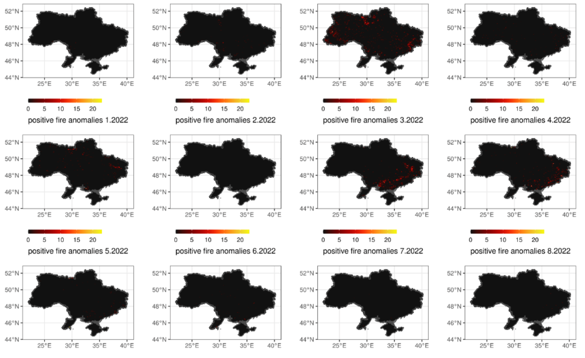
Using Remote Sensing to Assess Fire Anomalies in Ukraine
Authors: Emma Underwood and Daria Svidinska
Tags: 2022 Cohort, Career, Interviews
2022 Fire Anomalies in Ukraine Demonstrate Association with Military Action.

Developing a Personal Website
Authors: Crystal Wespestad and Divya Persaud
Tags: 2022 Cohort, Website, Portfolio
Personal website for Crystal Wespestad including core points of career and professional skills.

UK Residents Travel Trends Data Viz
Authors: Federica Moscato and Marta Villalobos
Tags: 2022 Cohort, Tableau, Data Visualisation
An interactive Tableau dashboard that allows the users to explore, visualize and compare the UK residents across the years. The main objective of this legacy project was to explore data viz tools

Population Analysis with Zonal Statistics
Authors: Mandy Maas and Priscilla Mbama Abasi
Tags: 2022 Cohort, Python, Statistics
Code calculating and visualising the population of districts in Madagascar using various python libraries.

Documenting ESRI’s Cartography MOOC
Authors: Charity Nduta, Sarah Kanee
Tags: 2021 Cohort, Cartography, MOOC
Video documenting experience undertaking one of ESRI’s MOOC. The MOOC was focused on the cartographic aspects of ArcGIS Pro. The overall experience was informative and the exposure to the cartographic capabilities of ArcGIS Pro was great.

Cracking Open the Technical Interview Black Box
Authors: Joanna Wilkin, Tova Perlman
Tags: 2021 Cohort, Webinar, Technical Interviews
A live webinar of panel speakers talking about their real world experiences with technical interviews, offering tips and tricks for how to complete interviews well, what to do when you can’t complete them and how best to answer technical questions. It included thoughts from interviewers on what makes a good technical interview for a job candidate.

Urban Heat Islands Mapping
Authors: Ghada Sahbeni, Yongyu He, and Aasia Wahab
Tags: 2021 Cohort, StoryMap, ESRI UC22, Climate Change, Sentinel 3
A comparative study about heat islands’ spatial distribution in two major European cities (i.e., Budapest and Munich) using Sentinel-3 SLSTR data acquired in August 2021.

Fighting Child Poverty in India
Authors: Yongyu He, Ghada Sahbeni and Aasia Wahab
Tags: 2021 Cohort, Article, Poverty, Zero Hunger, SDGs
A short article addressing child poverty worldwide and particularly in India. This article was published in Maplines spring issue 2022.

A Glance at Gender Equity in Education
Authors: Aasia Wahab, Ghada Sahbeni and Yongyu He
Tags: 2021 Cohort, Article, Gender Equality, Quality Education, SDGs
A short article addressing gender inequality worldwide and particularly in Pakistan. This article was published in Maplines summer issue 2022.

Satellite Imagery Evidence of Drought Effects on Lake Sevier, Utah
Authors: Alina Tarmu, Ambreen Masud
Tags: 2021 Cohort, Satellite, Leaflet, Python
A web page featuring a Leaflet map widget as well as a satellite imagery timelapse showing drought affecting Lake Sevier in Utah, USA.

Urban Mythbusters Volume 1
Authors: Deboleena Mazumdar, Mandy Maas
Tags: 2021 Cohort, Urban Myth, Amsterdam, Food
A geospatial exploration of tacos and tokos in the city of Amsterdam.

Lakes on Ice, from Space
Authors: Connie Harpur, Mandy Maas
Tags: 2021 Cohort, Google Earth Engine, Antarctica, Supraglacial Lakes
This blog post explores the use of satellite imagery in the Google Earth Engine Platform to detect and analyse supraglacial lakes in the Amery Ice Shelf in East Antarctica.

GIS Portfolio 101
Authors: Ayeisha Sheldon, Kathryn Berger, Tash Senior, Maria Rühringer
Tags: 2021 Cohort, ESRI Hub, Portfolio
Online webpage which highlights different aspects in creating a GIS portfolio, including examples and key resources for getting started. .

Highlighting the Hidden Figures of Women in the Geospatial Industry
Authors: Ariel Low, Helen Turvene, Aubin Douglas, Phoebe Ly
Tags: 2021 Cohort, Wikipedia, Women, Geospatial
We created Wikipedia pages to honour those women+ who have mapped the path forward, and to inspire the next generations of women+ geographers, mappers, and geospatialists.

The Sh*t You Don’t See on Someone’s CV
Authors: Alina Blume, Emma Pidduck
Tags: 2021 Cohort, Google Earth Engine, Antarctica, Supraglacial Lakes
CV with a combination of experience, both professional, but also personal to demonstrate the “real-life CV”

Cohort 3 Mentorship Network Catalog
Authors: Fernanda Ribeiro, Paige Krinks
Tags: 2021 Cohort, StoryMap, Survey, Statistics
An interactive catalog network of women from the 2021/22 mentorship cohort

Agriculture Commodity Mapping in Nigeria
Authors: Deborah Sobanke, Musa Chirikeni
Tags: 2021 Cohort, Tableau, Dashboard, Agriculture, Nigeria
Dashboard giving a full glimpse of cash crops produced in different states and LGAs in Nigeria. The commodities can be filtered by states or LGA to have a glimpse of where they are produced. The tree map gives a description of the highest producing state in Nigeria which is Kaduna state.

The Ocean in Focus
Authors: Ariana Yute, Ratna Prastyani, Annalie Agad, Iriz Angelica Rapacon
Tags: 2021 Cohort, Blog, Pollution, Marine, Indonesia, Philippines
The Ocean in Focus is a blog dedicated to increasing public awareness of marine debris in the oceans surrounding Indonesia and the Philippines. It compiles many resources about marine pollution and its effects, including interactive map.

Infographic on Women in Conservation and GIS
Authors: Alina Tarmu, Heather Peacock
Tags: 2020 Cohort, Article, Careers
An infographic that focuses on relevant statistics: numbers of women in these fields vs men; women of colour; the “leaky pipeline”.

Gender Dynamics in GIS
Authors: Dewi Spijkerman, Victoria Song
Tags: 2020 Cohort, Infographic, Video, Geography
Project looking at the gender dynamics and differences in opinions towards GIS as both a course and career option. Findings from a survey were summarised using an infographic and feature video.

Sustainable Development Goals
Authors: Argyro Kavvada, Darcy Gray
Tags: 2020 Cohort, StoryMap, Gender
A showcase of of projects addressing gender inequality through geospatial technologies and projects led by women in the geospatial field.

Capacity Building Database
Authors: Freja Hunt, Gemma Gass, Laure Boudinaud, Lorena Abad, Sofia Garcia, Tea Tuur
Tags: 2020 Cohort, Database, Training
A database of online courses to help you continue to build your expertise and keep up-to-date with the latest technological advancements and skills.

Urban Heat Islands
Authors: Laxmi Goparaju, Nontsikelelo Dupu
Tags: 2020 Cohort, Tutorial, Google Earth Engine
Research exploring the urban heat island effect in the Anthropocene age in relation to population, vegetation, urbanisation and climate changes.

#TheyMapThePath
Authors: Heather Kirkpatrick, Joan Vlasschaert, Kristen O’Shea, Melissa Sullivan, Nicole Yeung
Tags: 2020 Cohort, Social Media
A social media campaign called #TheyMapThePath. This campaign aimed to uplift and celebrate women; inspire geospatial communities; express gratitude.

The Geospatial Industry in Southern Africa
Authors: Deepthi Patric, Lynn Fanikiso
Tags: 2020 Cohort, Case Study, Geospatial
The state of the geospatial industry case study: Southern Africa

Map Challenge: Corporate Tax Havens
Authors: Katharine Hewlings, Kayla Rakes, Leah Bowyer, Olivia Wineski
Tags: 2020 Cohort, Video, Cartography
Map challenge: submitting a map to the Guerrilla Cartography map challenge. Map will be published in Shelter Atlas.

Detection of Vegetation Cover Change
Authors: Ghada Sahbeni, Kelebogile Basima and Sharon Omoja
Tags: 2020 Cohort, Research Paper, Land Cover
Study exploring the possibility of using NDVI classification derived from Landsat 8 OLI data to assess vegetation density change in Gospers Mountain between 2016 and 2020.

Studying the Geospatial Career Path
Authors: Elenora van Rijsingen, Esther Moore, Helen Whiteley, Katie Stenson, Stefanie Lumnitz
Tags: 2020 Cohort, Article, Careers
A survey distributed within the geospatial community with the aim to understand and visualize career paths of participants across the geospatial domain.
Celebratory Videos
At the end of each cohort a celebratory video marked the end of the programme, the video shares the work completed by the cohort and reflections on their time in the programme.

Celebrating the Women+ in Geospatial Mentorship Programme 2023-24
Celebrating the achievements and successes of the Women+ in Geospatial 2023-24 Mentorship Programme members!
Celebrating the Women+ in Geospatial Mentorship Programme 2022-23
Celebrating the achievements and successes of the Women+ in Geospatial 2022-2023 Mentorship Programme members!
Celebrating the Women+ in Geospatial Mentorship Programme 2021-22
Celebrating the achievements and successes of the Women+ in Geospatial 2021-2022 Mentorship Programme members!
Celebrating the Women+ in Geospatial Mentorship Programme 2020-21
Celebrating the achievements and successes of the Women+ in Geospatial 2020-2021 Mentorship Programme members!
Forging a geospatial community where all genders can thrive.Inspire. Unite. Empower.